
GoParksNewham launched the 'Discover the parks' walking and cycling route on Sunday 2 May. The route takes in many of Newham's parks using quiet roads wherever possible. The map is available online - park users can use it at any time to follow quiet routes between parks and discover all that Newham has to offer. With thanks to Newham Cyclists for helping us develop the route!
Find out about Newham's parks and friends groups on the GoParksNewham page, or you can also read historical information about the parks below.
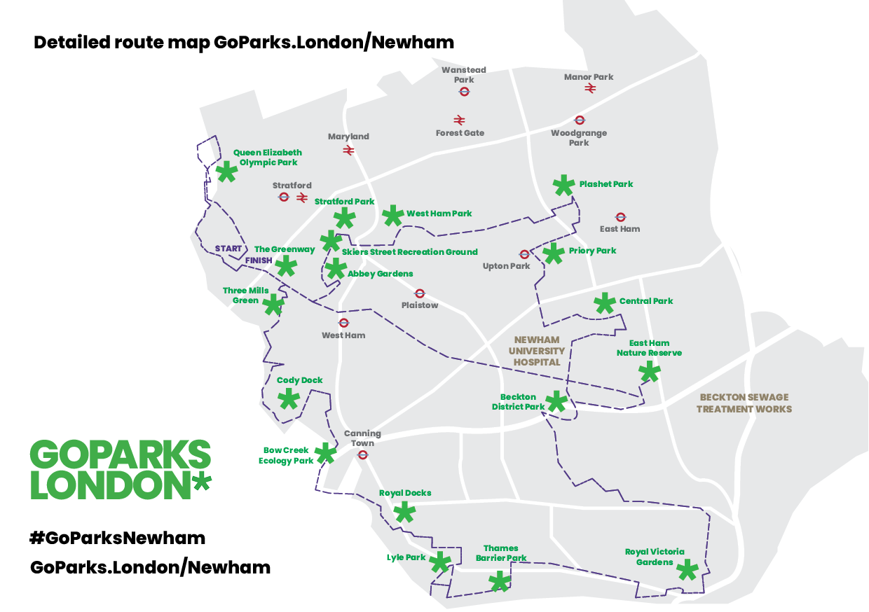
NEWHAM PARKS RIDE
Forest Gate Police Station is the spot in London furthest from a park.[1] Nevertheless Newham has a great variety of parks, and some are well hidden. This ride takes in some but by no means all.
This note contains information and points of interest along the ride provided to GoParksLondon by Newham Cyclists.
STRATFORD AND QUEEN ELIZABETH OLYMPIC PARK
Pre-Olympic Industrialisation
Much early industrialisation along the Lea valley occurred due to the use of water mills such as the Waltham Abby Gunpowder mills from as early as the 17th century. Temple Mills, at the north east corner of the park, is named after the Knights Templar who owned two water mills in the 12th century.
Part of the Bow China Factory pottery lay under the apartments known as Central House at the north east corner of the Bow flyover. This factory played a big role in the history of English porcelain. In 1744, Thomas Frye (1710-1762) and Edward Heyleyn patented a method of producing china of equal quality to that imported from the Chinese. The factory was sometimes known as "New Canton".
Due to the Metropolitan Building Act of 1844 noxious trades were banned from within the city limits of London, forcing factories to be set up just outside. While air quality was poor, the industrialisation provided lots of work opportunities, but work was tough and dangerous. Local residents were issued gas masks, such was the poor quality of the air.
In the Stratford area were Yardley’s (making soap) Berger’s (paint) and Clarnico’s sweet factory and towards the very end the notorious EU fridge mountain.
QUEEN ELIZABETH OLYMPIC PARK
The Park covers an area of 2.5sq kms. Some prehistoric settlements have been unearthed, including four iron age skeletons.
In creating the park, 2m tons of soil were cleaned, 5kms of riverbank were cleaned, power cables buried underground and an EU fridge mountain ("one of Europe's most iconic eyesores") removed. 250 ha (500 acres) of parkland were created. The north part of the park is more like traditional parkland. The southern section is more "urban" and can be used for events.
The ArcelorMittal Orbit : A 376 foot tall sculpture come observation tower, designed by Turner prize winning sculptor Sir Anish Kapoor and engineer Cecil Balmond. It is said to be inspired by the Tower of Babel. As a late addition to the Olympic Park, it was mostly paid for by Lakshmi Mittal.
The Aquatic Centre; Designed by Zaha Hadid Architects. Zaha Hadid was a Bagdad born and London trained architect of world repute, but who has completed a few UK buildings. Another is the recent extension to the Serpentine Gallery. The Aquatic Centre uses her trademark curves, and is said to be inspired by water in motion. Whatever its inspiration the roof presented an engineering challenge. The building was in fact designed before the Olympic bid was successful and therefore had to have extra seating wings added for the Games. Reputedly the Centre cost £50m more than the original budget of £249m. It has been funded to be run by Greenwich Leisure.
The Copper Box: The Handball Arena during the Olympic Games, this venue was designed by MAKE architects and uses recycled copper for its cladding. Now a leisure centre, run, like the Aquatic Centre by Greenwich Leisure. It has seating for up to 7,000 and is the new home of the London Lions Basketball Team. It also hosts a Grand Prix Badminton tournament.
The Velodrome: A hyperbolic paraboloid-shaped steel framed structure sits on a 360 degree glazed concourse, the whole being clad in timber to allow natural ventilation. Designed by Hopkins architects it was the first completed venue for the Olympics. It had seating for 6,000 during the Games. Now the centrepiece of cycling facilities including the outside road, BMX and mountain bike courses, and it has been taken over by the Lea Valley Regional Park Authority.
The Energy Centre (not in Newham): Providing heating and cooling for the games and district heating as a legacy, plus providing power to the national grid. They utilise Combined Cooling Heat and Power systems with biomass boilers. Designed by John McAslan and Partners they utilise a rusty facade.
Stratford Box Pumping Station: Lyall Bills & Young’s Stratford Box Pumping Station in the Queen Elizabeth Olympic Park is said to be at once sculptural, enduring and integrated into the landscape. It was built to relieve groundwater build-up caused by changes in the water table, avoiding flooding of the Eurostar/HS1 line.
THE GREENWAY
The Greenway was constructed on the Northern Outfall sewer, which itself was built as a response to the ‘Great Stink’ of July and August 1858 which had been preceded by outbreaks of cholera. By June that year the stench from the river had become so bad that business in Parliament was affected, and the curtains on the river side of the building were soaked in lime chloride to overcome the smell. The Great Stink was a result of the increasing pollution of London’s rivers including by the introduction of flush toilets, over filling the drainage system that was only designed to keep rainwater.
It was built by Joseph Balgazette, part of a 1,300 mile network of sewage pipeline as five interceptor sewers, three of which were built by Balgazette. The Greenway lies on top of this network. It is 7.1 kilometres long, or 4.4 miles from Victoria Park to Beckton.
ABBEY MILLS
Abbey Mills Pumping station was designed by Joseph Bazalgette with architect Charles Driver in a cruciform Byzantine style. "The cathedral to sewage" was built in1868. Described by Pesvner as “one of the most splendid sights along the flat, marshy, creeks and channels between the rivers Lea and Channelsea, with exciting architecture applied to the most foul purposes.” The building is in a number of styles. Two chimneys resembling Moorish minarets were removed during the Second World War.
It is a Grade II listed building. From here sewage was pumped between two low level sewers and the Northern Outfall Sewer. It contains electric pumps now to back up the modern facility.
The modern pumping station was designed by Allies and Morrison.
During the Second World War, two A/A guns were also positioned on the sewer bank, and a pillbox, which still remains.
Towards the end of the Greenway, by the East London cemetery is an archway known as the Devil’s Canyon’. It’s a disused railway arch possibly built on an earlier cemetery, under which lie broken gravestones.
WEST HAM MEMORIAL PARK
Memorial Recreation Ground opened in 1897, and was the playing fields where West Ham United Football Club originated, the club also using Hermit Road Recreation Ground, before moving to Upton Park in 1904. The Memorial Ground is the home of the East London Rugby Club.
The name of the underground station was changed to West Ham when they played here. It contains a statue commemorating Thames Ironworks, from which the football club was founded. Some original gates, painted claret and blue, survive in adjacent Grange Rd.
ABBEY GARDENS
Stratford Langthorne Abbey
In 1135 William de Montfitchet, successor to Robert Gernon, founded the Cistercian abbey of Stratford Langthorne about ½ mile south of what is now Stratford High Street. At the time, Stratford was then part of Essex. This Cistercian monastery was also often called West Ham Abbey after the parish in which it was located.
Among the abbey's earliest endowments was Woodgrange, an outlying farm on the edge of the forest, first mentioned in 1189. Stratford became a rich and important house, often visited by royalty, especially in the 13th and 14th centuries, and probably used as an administrative centre for south-west Essex. It steadily enlarged its estates in West Ham, and by the 15th century controlled most of the parish. The abbey precincts, beside the Channelsea, included a few industrial buildings and private dwellings as well as the conventual buildings; but the Cistercian tradition of isolation was not without effect, for Stratford Abbey, unlike those of Barking and Waltham Holy Cross, did not attract settlement outside its walls.
By the times of Henry VIII, Stratford Langthorne was reputed to be the fifth largest abbey in the entire country, making it a prime target during the dissolution of the monasteries.
The Abbey was supressed in 1538. The deed of surrender of the Abbey, which still exists in the “Public Record Office” in London, was executed in the Chapter House of the Abbey on the 18th March 1538, and it was signed by William Huddleston, the last of the Abbots, the Chanter, the Sacrist and eleven monks.
Over the years, the Abbey buildings were dismantled and their materials used to build other structures in the area. You can therefore only see some remains of the 12th century abbey gatehouse in West Ham at Abbey Gardens. The gardens surround part of the abbey ruins. The Victorians used the site for part of the North Woolwich railway track and built factories on the free space.
Since the 1970s, there have been periodic archaeological digs on the site, usually during redevelopment projects in the area. These digs have helped archaeologists better understand the layout of the abbey. A series of over 600 burial excavations at Stratford Langthorne is thought to be the largest example from a Cistercian monastery in all of Europe.
Among the abbey remains uncovered during the excavations were parts of the great drain, a foundation and a grave on the site of the church, a cellar or a small fishpond and possibly part of the infirmary, while planting pits provided evidence for monastic gardens on the eastern edge of the abbey precinct. However, the archaeological highlight was undoubtedly a community excavation carried out by local residents on an overgrown plot of wasteland on the north side of Bakers Row (now Abbey Gardens). The dig was organised by Newham Council and Museum of London Archaeology with the aim of uncovering the remains of a medieval stone building first discovered by archaeologists in the early 1970s, but then reburied for their protection. It was hoped that after consolidation, the masonry would be robust enough for permanent display.
When first discovered, the building was thought to be the abbey gatehouse or Great Gate, which after the Dissolution was converted into a dwelling and survived until about 1825. However, the building was soon reinterpreted as an abbey guesthouse, for it appeared to be too small to be the gatehouse, and in any case it did not seem to straddle the access road to the abbey (perpetuated today by Bakers Row).
Work in a previously unexcavated strip on the south side of the medieval building revealed stone walls extending out towards Bakers Row. From this it was clear that the building was much larger than had been thought, and that it had been constructed in two phases. It was also evident that the building would have crossed the line of the access road to the abbey precinct. So it was the gatehouse after all.
After the Dissolution the gatehouse was further extended and modified for use as a secular dwelling. Brick cesspits were built next to it in the 16th/mid-17th century and the mid-17th/18th century. A stretch of the great drain was rebuilt on a smaller scale, possibly in the late 16th or 17th century, and continued in use into the 19th century. Other post-medieval features included several 16th- to 18th-century pits, the remains of a 17th-century brick building, garden walls, a possible well, moat fills and a late 18th-century/early 19th-century brick cesspit possibly associated with the converted gatehouse. The latest features were the remains of Victorian terraced houses fronting onto Bakers Row.
All Saints West Ham Parish Church displays a stone window and a carving from the original monastery. You can also see an example of the abbey’s coat of arms in Stratford on the Old Court House doorway.
STRATFORD PARK
West Ham Lane Recreation Ground opened in stages between 1899 and 1912 as the Borough Council acquired parcels of land for its new park. The first section next to Whalebone Lane was once part of the grounds of a grand house that had belonged to the Archdeacon of Essex and the estate included land and houses on the west side of West Ham Lane. The freehold was sold to West Ham Council in 1899. The recreation ground was probably the last in the series of parks created in West Ham in the 1890s as part of an initiative to provide public open space as the area was developed for housing. The park was renamed Stratford Park in the late 1990s.
WEST HAM PARK
The largest park, other than the Olympic Park, in the London Borough of Newham, opened to the public in 1887. One of the most beautiful parks in the borough, it was laid out on the former grounds of Upton House, an estate dating back to the C16th. From 1762-80 it was owned by Dr John Fothergill, a Quaker physician and noted botanist, who planted a famous botanic garden here.
Spanning 77 acres (31 ha), the park has been managed by the City of London Corporation since 1874. They stepped in when Ham House was being sold off.
PLASHET PARK
Plashet Park was opened in 1891 with land taken from the former grounds of late 18th Century manor, Wood House, acquired for £3,000. Prison reformer Elizabeth Fry had formerly lived nearby in Plashet House. In 1964 a small zoo was added, and was later expanded with a butterfly house and aviary as well as enclosures for rabbits, Vietnamese potbellied pigs, wallabies and Shetland ponies. Sadly this was closed in the 1990s, depriving newer residents of the chance to enjoy the legendary ‘pheasant phenomenon’.
PRIORY PARK
There is no “Upton Park” as a green space. Priory Park is the nearest we get.
This narrow park, weaving between housing, lies in an area deficient in accessible wildlife sites. Priory Park won a Green Flag Award again for 2008/9.
THE CENTRAL PARK
This attractive, mature park is by far the largest open space in densely built-up East Ham. Central Park won a Green Flag Award again for 2008/9.
Between 1851 and 1911, East Ham’s population had grown from 1,737 to 133,487, driven by the arrival of the railways in 1858 and a search for jobs around the Royal Albert Docks, Victoria Docks and the Beckton Gasworks. In an attempt to counterbalance this urban invasion of what had formerly been grazing land, John Harvey Bethell – first mayor of East Ham Borough – united with William H. Savage, the district surveyor for East Ham, and local landowner Col. Ynyr Henry Burges, Lord of the Manor and owner of Rancliffe House, to create Central Park. Seventeen acres of land around Rancliffe house were bought for £8,500 and then another eight acres for £4,000. The development also included a large number of houses designed for clerks and skilled workers.
The park was opened on 5 July 1898. 7,000 attended the event, enjoying refreshments and speeches stressing the importance of creating resources for children to prevent ‘Jack becoming a dull boy’. The original park consisted purely of walkways and a fountain but later incorporated public baths, a sundial, a bowling green, glass houses and a putting green. Other highlights added later included the present war memorial, a small railway that carried residents round the park, and the park dances that used to take place during the Second World War and then again in 1948.
The memorial in Central Park, East Ham, was erected in 1921 to commemorate the many men of East Ham who fell during the First World War. The memorial was designed by the architect Robert Banks-Martin, who was the mayor of East Ham during the war.
The memorial stands in the south-east corner of Central Park. It is of Portland stone and takes the form of an elaborate cenotaph which stands on a three-stepped base; it is approximately 8 metres tall. The lower part of the monument is square in section, each face having a curved head topped with a faceted pinnacle. Above, four columns rise from the corners of the monument, linked at the head by round arches with pronounced keystones. From each of the keystones on the north and south sides hangs a bronze wreath. The monument is surmounted by a stone dome with a faceted pinnacle.
Each face of the memorial bears a bronze plaque; the plaques are dedicated to the men of East Ham who fell during the First World War, and specifically, the men of the 32nd (S) East Ham Battalion The Royal Fusiliers and the men of the 141st (East Ham) Heavy Battery Royal Garrison Artillery. The Roll of Honour is spread between the four sides of the memorial and contains a total of 1,824 names.
EAST HAM NATURE RESERVE
The churchyard was officially closed for burials in 1974 and was a wilderness until its value as a wildlife reserve was realised in around 1977. In 1981 hedges were planted, a copse of Scots pines was planted and the Visitors Centre was built. It is now managed as East Ham Nature reserve, which is an important teaching resource for Newham schools.
St Mary Magdalene Church was built in around 1130 and is one of the oldest in the country, its 9 acre churchyard one of the largest in London. The ancient parish church indicates where the medieval settlement of East Ham was centred; it is also near the site of a Roman cemetery discovered in 1864. The church is remarkable in retaining its original Norman form complete and has a number of medieval features.
BRAMPTON PARK
Opened in 1915, 3.6 hectares simply laid out with a pergola near the main Masterman Road entrance.
BECKTON DISTRICT PARK
Landscaped in the early 1980’s, together with King George V Park, it forms Beckton District Park and Newham City Farm, a Site of Borough Importance for Nature Conservation, Grade II.
THE ROYAL DOCKS
The Royal Docks are a collection of three docks, Royal Albert, George V and Royal Victoria. Despite being named after the monarchy, they are not owned by the royal family. They were completed between 1855 and 1921, by St Katherine’s docks company. Spanning over 12 miles, the docks were responsible for the majority of imports and exports to and from the city. As a result large granaries, warehouses and storehouses were built along the river.
Collectively the largest enclosed docks in the world, occupying a space the equivalent to the whole of central London from Hyde Park to Tower Hill. Victoria Dock was built 1850-5 by the Victoria Dock Co. and designed by George Parker Bidder, a civil engineer from Devon. An advance on earlier docks by virtue of its size, its own railway system and the extensive use of finger jetties to increase capacity. By 1860 the dock was taking in 850,000 tonnes of shipping per year.
The Pontoon Dock was built towards the end of the construction of the Victoria Dock and included a revolutionary ship lift, which lifted each ship out of the water on pontoons that were raised by hydraulic jacks. Drained of ballast water the ship could then be floated to a finger dock for repair. By 1896 the size of ships became too great for this manoeuvre. The docks usage was shifted to grain storage as most new vessels were too large to be serviced in the dock.
The Albert Dock was built 1875-80, which has 85 acres of water.
The Royals were taken over by the Port of London Authority in 1909. The George V Dock was one of two planned for the north and south of the Albert Dock by an1901 Act of Parliament. It was built 1912-21, and has 64 acres of water.
During the General Strike the generators of two Royal Navy submarines were connected to the warehouses to save 750,000 frozen carcasses.
The docks were heavily bombed during the war; it is estimated that 25,000 tons of ordinance was dropped on the Royal Docks during the Blitz. The docks remained open despite high casualties of many dockers working during air raids. Following the war the docks briefly recovered as a commercial hub, but with the advent of the far more efficient method of containerization, which allowed cargo to be transported much easier on land, the docks eventually ceased commercial activity in 1981.
Several of the granaries and mills were damaged by the Silvertown explosion in 1917. Many dockside buildings were demolished to prepare for a commercial development, Silvertown quays, which has not materialised.
ROYAL ALBERT DOCK PUMPING STATION
Probably dates from c1930.
BARGE HOUSE ROAD
Council housing provided by the Borough of Woolwich in 1901.
VICTORIA GARDENS NORTH WOOLWICH
Although gifted by King Edgar to a local nobleman, by 1086 East Ham, including the marshes of North Woolwich was known to be held by Westminster Abbey, as the abbey’s manor of ‘Hammarsh juxta Barking’.
It remained in religious ownership right up to 1840 when the railway proprietor George Parker bought the land so he could extend railways to the ferry — and built North Woolwich railway station.
The gardens themselves were laid out as a Victorian pleasure garden by a hotel opposite the railway station, the Pavilion Hotel, in 1850, and although initially hugely successful, by the 1880s the gardens were losing money, and there were proposals for them to be converted into industrial use.
Fortunately, a public appeal lead by the Duke of Westminster was able to raise the £19,000 needed to buy the land for it to be permanently laid out as a public garden and in April 1890 it was handed to the London County Council.
There is a quirk in that this patch of land north of the Thames known as North Woolwich was, until 1965, part of Kent, not Essex. This is thought to have been a legacy of the Norman conquest when the Sheriff of Kent, Hamo Dapifer, was gifted land in Essex, and he managed to somehow attach that to his estates in Kent — and tax the ferry linking the two.
However, in 1888, North Woolwich was split in half by the park itself, which became part of East Ham – leading to a peculiar peninsula of political power in this part of London. In 1965, this mess was tidied up at last, and now the entire north bank of the Thames along here is united in the Borough of Newham.
Nothing remains of the Victorian pleasure gardens, and what’s here is largely how the gardens were laid out in 1890, with a series of paths for decorative Victorian walking, and a high raised back next to the river giving a pleasant riverside walk, even if the riverside wall is a rather unpleasant concrete anti-flood necessity.
The only noticeable piece of docklands history here is a large steam hammer from a local ship repair dock. One thing which was added in later years, but is now missing is an open air swimming pool that used to sit between the bowling green and tennis courts.
Visible from the gardens are the North Woolwich Pumping Station of 1895-7, built as part of an LCC main drainage project and the managers house.
NORTH WOOLWICH OLD STATION
Built 1854 as the terminus for the Eastern counties and Thames junction Railway. Converted to a museum but now derelict.
BRICK LANE MUSIC HALL
Formerly St Mark’s Church. It was built in1860-62 by architect SS Teulon. Now sympathetically restored as the Brick Lane Music Hall. Described by Pesvner as “confident, massive, exotically decorative, in deliberate contrast to its industrial setting.”
THAMES BARRIER PARK
Thames Barrier Park is a 7-hectare green space located in the Royal Docks - an area in the London Borough of Newham. The park is managed by the Greater London Authority. Opened in November 2000 it was London’s largest new riverside park for over 50 years.
Thames Barrier Park was designed by landscape architect Allain Provost (Groupe Signes) of Paris and architects Patel Taylor of London. Remarkably, the park was created on a site that once housed petrochemical and acid works on the Thames riverbank. The contaminated soil was covered with a 6 foot layer of crushed concrete to protect the new soil laid on top. Since its opening the park has won design awards in the UK and USA.
One of the most eye-catching features of the park is the 'Green Dock', a 130 foot long sunken garden running diagonally through the park that is intended as a reminder of the site's dockland heritage. The 'Green Dock' provides a wind protected microclimate for a variety of plants and wildlife.
Two bridges cross the Green Dock and reveal vistas across the colourful, scented gardens. The park also boasts extensive lawns that are crossed by gravel pathways and bordered by yew and maygreen hedges.
The park is carefully tended to display variety throughout the year, and provide a welcome habitat for birds and insects.
At the Riverside is a memorial to the civilian victims of war.
THAMES BARRIER
Flooding in London has been a problem since the city was first established in Roman times. In 1954 the Waverley Committee, established to investigate the serious North Sea flood of 1953 which affected parts of the Thames Estuary and parts of London, recommended that "as an alternative to raising the banks, the possibility and cost of erecting a structure across the Thames which could be closed in a surge should be urgently investigated".
The concept of the rising sector gates was devised by (Reginald) Charles Draper. In 1969, from his parents' house in Pellatt Grove, Wood Green, London, he constructed a working model. The novel rotating cylinders were based on the design of the taps on his gas cooker.
Work began at the barrier site in 1974 and progressed in two phases. The southern piers (9 to 6) were built first, with river traffic diverted to the north side, then traffic routed through the completed southern spans whilst the north side piers (1 to 5) were built. During construction of the piers, precast concrete sills were built in a cofferdam on the north side of the river and floated out and sunk between the piers to form the gate recesses, with access tunnels at the upstream and downstream ends.
The gates of the barrier were fabricated in sections at Cleveland Bridge's Darlington works and assembled at Port Clarence on the River Tees. The gates, gate arms and rocking beams were transported from the Tees to the Thames by barge and lifted into position by two very large floating cranes operated by Neptun of Hamburg (now part of SMIT). The mechanical and hydraulic machinery was built by Davy Loewy, Henry Berry and Vickers and trial assembled in Davy's Darnall works. Delays to the civil works required changes to the construction and installation sequence, but commissioning was relatively uneventful and the first trial operation of all the gates together was carried out on 31 October 1982.
In addition to the barrier, the flood defences 18 kilometres (11 mi) down river were raised and strengthened. The barrier was officially opened on 8 May 1984 by Queen Elizabeth II. The barrier cost £461 million (£1.16 billion now). Total construction cost was around £534 million (£1.6 billion at 2016 prices) with an additional £100 million for river defences.
The barrier protects central London against a storm surge, caused when a deep depression forms to the north of Scotland and progresses across the North Sea and south-easterly towards southern Scandinavia. When such a surge coincides with a high spring tide, the high winds associated with the depression can funnel the water up the Thames Estuary and cause surges of up to 3.5 metres. The planners assessed that in the absence of a barrier, such a surge could inundate 45 square miles (117 km2) of land, put hospitals, powers stations and the London Underground out of action and cause damage estimated in 1966 at £2.0 billion (about £50 billion at 2020 prices). The barrier was designed to provide a flood defence capable of resisting a once in 1,000 year surge tide at a base date of 2030.
The Silvertown Explosion
In 1917, just before seven o'clock in the evening, London's biggest ever explosion occurred.
The location was Silvertown, between the Royal Docks and the Thames, and the cause was munitions work for the Great War. A former caustic soda factory on the waterfront had been taken over for the production of TNT, and on Friday 19 January 1917 it exploded. 73 people were killed and more than 400 injured, which is the kind of mess 50 tons of high explosives can make in a built-up area. So great was the blast from the Silvertown Explosion that 900 adjacent properties were destroyed, the windows at the Savoy Hotel were blown out, and the bang was heard as far away as Norfolk and the Sussex coast.
A memorial to the disaster was erected by the company outside the factory gates, and stood until recently under the DLR viaduct on the North Woolwich Road. It doubled up as a war memorial, so only one of the four faces commemorates the explosion, and only employees of the company got a mention, which isn't ideal. It was also carved from limestone, so the lettering hasn't fared too well in London's polluted air and has become increasingly hard to read. Meanwhile the site of the explosion remained barren wasteland until a couple of years ago, deliberately undeveloped, before bowing to inevitable commercial pressure.
LYLE PARK
In 1924, Sir Leonard Lyle, a grandson of Abram Lyle (the Lyle of Tate and Lyle), donated the land to the local council to be used as a park for the benefit of local residents. It contains a First World War Memorial in the form of a water fountain and the gates that stood at the entrance to the Harland and Woolf shipyard in Woolwich Manor Way. Installed here as a decorative feature in 1994.
BOW CREEK ECOLOGY PARK
The park was created by the London Docklands Development Corporation (LDDC) in 1994, after a survey identified rare and unusual plant species in the area, some presumed carried in by shipping, such as Hairy Buttercup (Ranunculus sardous), Walthamstow Cress, and Unreel's Wormwood.
The park has won a Green Flag Award for the fourth year in 2010, and was also nominated for the UK Landscape Award 2010.
CODY DOCK
Originally built in the 1870’s as a dock bringing coal to the Bow Gasworks, it was developed by the Imperial Gas and Light Coke Co (later taken over by the Gas Light and Coke Company). After falling into disuse and being used as an informal dump, it was acquired by the Gasworks Dock Partnership as a Social Enterprise with a vision to provide employment, educational and cultural facilities - particularly the creative arts. Its first open day was July 2012.
The name "Cody" for the dock and the nearby road derives from the fact that "Buffalo Bill" Cody pitched his camp in the area when he was giving shows in London. It is a key site for opening up the Lower Lea Valley to walkers and cyclists. It is being re-developed as part of a community project, into a working marina, under the Cody wilds project. The project is being led by the Gasworks Dock Partnership. The aim of the development is to deliver a sustainable creative industry hub, promote community value and increase participation in the arts and access to the diverse ecology of the river Lea for local community groups.
MEMORIAL GARDENS
Located in the area of the Bromley Gas Works, this garden includes the memorial to Sir Corbet Woodall, the Governor of the Gas Light and Coke Company from 1906 to 1916. From Liverpool he followed his father into the coal gas industry working at Woolwich, Stockton-on-Tees and Vauxhall before becoming a consultant gas engineer. When he became a director of the Gas Light and Coke Company it was the largest gas company in the world. It had been founded by Royal Charter in 1812 and was the first company to supply coal gas in London, operated the first gas works in the United Kingdom and was the world's first public gas works. Its first works were located at the Royal Mint. The Company was capitalised at £1 million for 80,000 shares, which approximates to £7 billion in modern currency.
The company absorbed numerous smaller companies such as the Aldgate Gas light and Coke Company, the City of London Gas light and Coke Company. It eventually ended up supplying an area from Pinner in North West London to Southend on Sea, it was nationalised in 1948 under the Gas Act and became one of twelve large regional gas boards. The gas boards were replaced by British Gas in 1972.
Sir Corbett Woodall was famed for fostering good relations with his staff and was honorary colonel of the 12th Battalion of the London Regiment. He retired to the south of France in 1914 and died 2 years later. The statute is by George Arthur Walker. They are accompanied by war memorials and a lit gas light.
The statue (which was moved from Beckton in 1926) and war memorial are Grade II listed.
THREE MILLS
The Three Mills are some of the earliest examples of a tidal mill system in Britain. They were acquired by Stratford Longthorne Abbey in the 12th century. Prior to the abbey, there is evidence in the Doomsday book of eight or nine mills situated on the same site.
During the period of dissolution of the Abbey the mills were producing flour for the bakers of Stratford-atte-bow. During the 16th century the three mills were reduced to two, the ‘House Mill’ and the ‘Clock Mill’, with production shifting to the grinding of grain used in the distillation of alcohol to produce gin. The House Mill was rebuilt in 1776 following a fire and is now a Grade 1 listed building, built for James Bisson.
The Clock Mill was rebuilt in 1815-17 by Philip Metcalfe who was a Tory MP and owner of Metcalfe and Co, a distillery based in West Ham.
The Mills would change ownership frequently until 1872 when they were purchased by distillers J & W Nicholson and Clerkenwell, and continued in operation until closure during the 2nd World War in 1941. The mills were bombed during the war; the Millers House was totally destroyed and only rebuilt in 1995.
The Mills remain the largest tidal mills in the world, but are not in operation. The building is owned by the House Mill Trust and is one of only four Grade 1 listed buildings in Newham.
The Mills share the island with Three Mills studios, formerly known as Bow Studios during the 1980s. In 2004 the London Development agency acquired Three Mills Studios, and the ownership was transferred to the LDDC in 2010. Some of the more famous films that have been produced at Three Mills are: Fantastic Mr Fox, Lock Stock and Two Smoking Barrels and Made in Dagenham.
Abbey Lane Open Space
See info on Abbey Gardens
[1] Diamond Geezer 25 June 2020